Yury
-
Posts
6 -
Joined
-
Last visited
Yury's Achievements
")
Wolf Bait (1/9)
5
Reputation
-
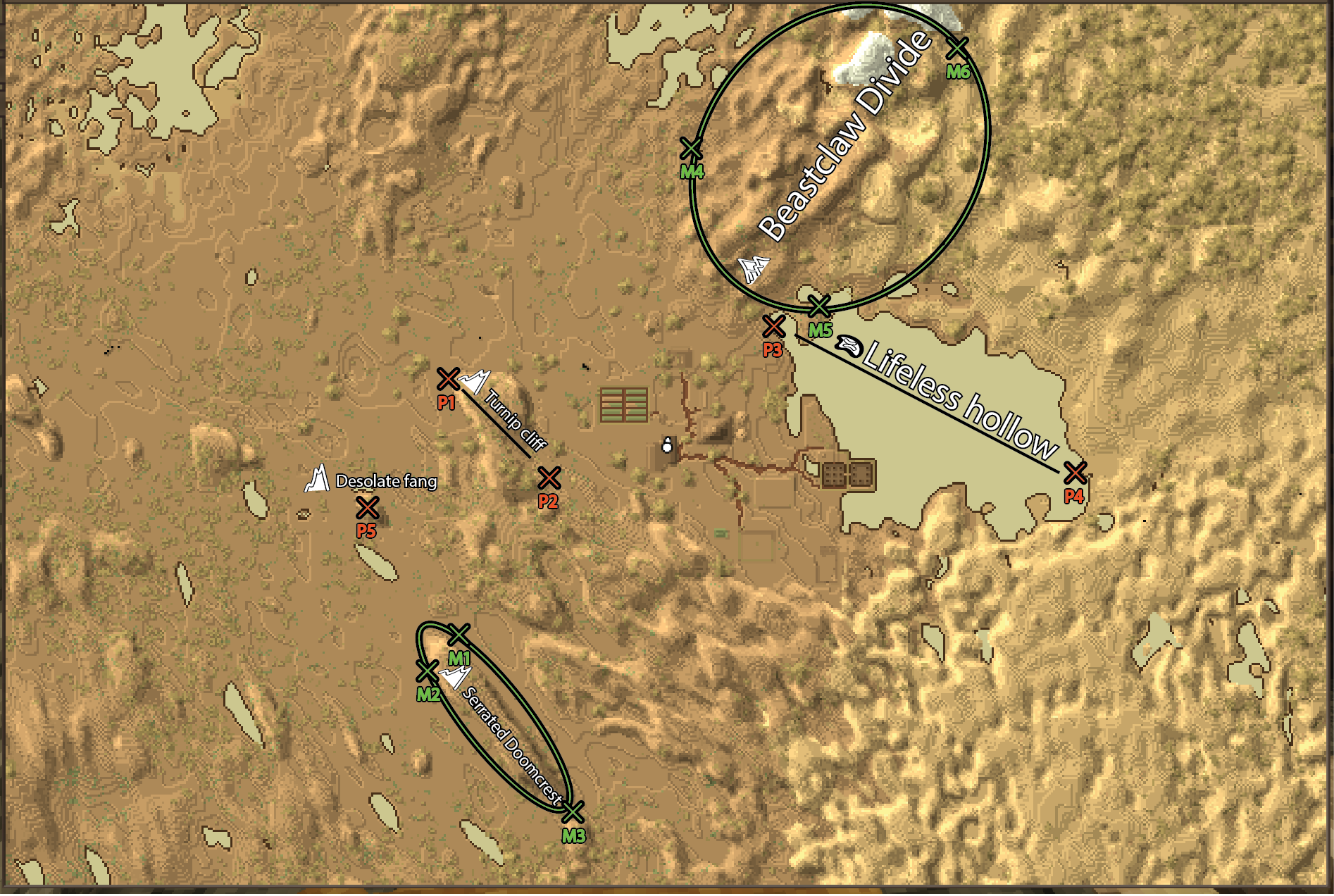
My hat is off for you, my dear seraph! Navigating without a map is amazing, but I can't see how I would play with my partner without using map for reference (unless we have names for objects! On a map, pinned on a wall at base, sized 3*4 blocks! But that's for different suggestion) I believe it's a bit early for pseudo-code, since I see at least 4 different ways of selecting areas on the map. Below I will describe only two ways that's are not automatically naming every feature, but rely solemnly on user input. Automatically identifying features could be a bit tricky, so maybe rely on user for that instead. I'd rather focus on where and how stick the pictogram and label. Objects on all maps can be divided into point and 2D spatial features (and if we zoom out long enough, 2D spatial feature becomes point feature). VS is covering point features good enough for now, so I want to focus mostly with 2D features (lines or areas) to name, not point-features. So, on edited screenshot in color I'm illustrating how this naming could be done, using two different approaches, each illustrated in its own filling color - orange for 2-point, and green for ellipse-based 3 point. All lines and points that have filling other than white shouldn't be visible for user after creating feature name. So regarding 2 manual algorithms to name 2D features on the map - here's the first. The user provide only two points. So for example, P1-P2. These points would be then connected by an invisible line, in which the label for a feature should be fitted by adjusting font size within limits, say from 8 to 18. Names ideally should be generated from a library - adj+noun, offering 3-5 options or waiting for user to write its own, while pictogram next to the name for user themselves to choose - just one of a few types (cliff, single mountain, mountain range, valley, plateau, large body of water for ocean/lake, swamp, etc). On screenshot P1-P2 - label defined by me because that's the feature name we are using through our >100 hour base, while P3-P4 is something I'd like to see coming from the generator. If distance on the map between points is short and text falls below predefined font size, text label should be hidden from the map. Other, and a tiny bit more complex algorithm - user should select 3 points on the map (green filling on screenshot, points labelled with M for marker). Through 3 markers M1-M3, the script should fit an ellipse with minimal circumference. The pictogram and feature name should be then limited to fit within the ellipse, following the same rules about min-max font size. This algorithm could be a bit more upscaled for features of more complex geometry, relying on multiple points and smoothed polygon touch each point. In that case, the polygon can be somewhat highlighted on the map, but it may crowd already crowded maps.. Guys. let me know the questions you have, or how otherwise I can make to contribute for this function to come to live. If pseudocode is something I can offer, then pseudocode it is. But which of the two options would you prefer? Or should I describe possible automatic feature naming algorithms I came up with, even though I'm a bit on the fence about automating it?

-
Thanks, I appreciate interest. Now the question, I feel like I should explore an option of doing it as a mod for beginning, but I have no experience in C# and VC modding, I feel like just editing json won't cut it. Any other thoughts? How do I get started? I glanced over wiki manual, seems like someone with experience could really help me get started
-
Hi all, I would like to have an ability to manually add names to the objects on the maps - lakes, mountains, oceans, valleys etc. Ideally, names could be automatically generated from vocabulary, pairing adjective with noun, and such name should be a) visible on the map without hovering the cursor over the feature and b) shared between server clients. Creating the feature name could be done by defining 2 points - start and end, between which the text would fit, adjusting font size to take most of the space. I think it would be easier to tell friend that your loot is in a cave under the Cursed Mountain, and you're rushing the base going north of Woozy wolf lake?
-
 Yury changed their profile photo
 -
howdy, folks. I feel like I can work on the improvement of the ore generation (as someone, who's working in geological survey and seeing hundreds of exploration projects unfolding, plus with PhD in ore forming processes, I believe I am the guy who can contribute). The problem though, is that I don't know where to start, and I need some hand-holding. I read the wiki about mods and all, but maybe I'm too old (old school), I do need human input for starter. I want to work on that myself or contribute to a team work, and I have some coding experience, but it's mostly in Python with a bit in Java, and in very specific research projects. I bet there is something similar planned in the future, but hey, why wait if I can do it? Any help?
-
TLDR: 5 barrels used to process hides, placed outside, disappeared without any trace after ~1 year in-game. details: I'm playing the save file since 1.15.6 (or .7, can't tell) in localhost from time to time. Today I updated to 1.15.9, and start playing - barrels were in place (2 of them were sealed in previous save with hides in strong tannin, others with weak tannin stood open). I mind my own business, got one small hide and sealed in it limewater barrel, and went off a few chunks for 1 in-game day to chop the trees with my partner. After coming back my partner found that barrels are gone, and restarting the map didn't help, the field where they were just empt. Not much lost, but it's a bug regardless (or feature - barrels after ~1 in-game year falls apart if installed outside?)
-
I checked if there are suggestions for snowman, and didn't find anything, however, apologies if it was already suggested. The idea is to introduce snowball, and ability to accumulate them by "rolling" it over snow-containing blocks on flat surface. And then stacking rolled large snow balls to form snow mans (with the same sculpture mechanic available for rocks), snow fortresses. If I'd have right coding background, I would make mod with this content. Cheers, guys!